
12 Best Hikes Near Valencia: Canyons, Caves & Mountain Views
When people think about Valencia, hiking probably isn’t the first thing that comes to mind.
Beaches?
Yes.
Paella?
Obviously.
The City of Arts and Sciences?
Of course.
But drive away from the city and Valencia changes surprisingly quickly.
Within roughly an hour or two, you can be walking through deep river canyons, crossing hanging bridges, following a Roman aqueduct through tunnels cut into rock, swimming beneath waterfalls or squeezing through a natural hole in a mountain before emerging above the Mediterranean.
And some of the best routes are places many international visitors have never heard of.
We’re not interested in giving you twelve almost identical forest walks.
These are routes we’d choose because each offers something different.
For hanging bridges: Chulilla
For history: Peña Cortada
For cliffs and river canyons: Montanejos
For caves and waterfalls: Buñol
For adventure: El Garbí
For a natural mountain tunnel overlooking the sea: Forat de Bèrnia
For a serious challenge: Barranc de l’Infern
For hidden Mediterranean coves: Cala Llebeig
Here’s how we’d choose.
1. Chulilla – Hanging Bridges & the Turia Canyon
Best for: dramatic scenery without an extreme hike
Difficulty: Moderate
From Valencia: roughly 1 hour
Highlights: hanging bridges, canyon, Turia River
If friends were visiting Valencia and asked us for one hiking day that feels completely different from the city, Chulilla would be very high on the list.
The village itself already has a spectacular setting, sitting above the Turia River and surrounded by steep rock walls.
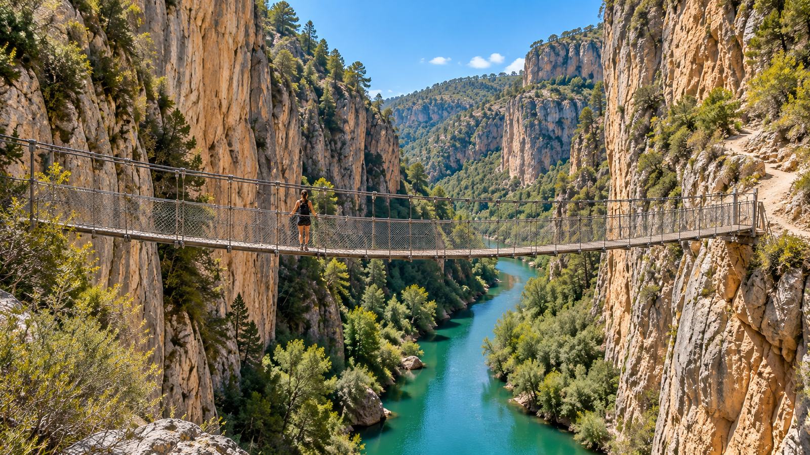
But the reason most hikers come is the famous Ruta de los Puentes Colgantes, also known as the Ruta de los Calderones.
The path enters the Hoces del Turia and crosses the gorge using hanging bridges suspended above the river.
That immediately makes the route more interesting than an ordinary countryside walk.
The landscape does the rest.
Rock walls rise around you while the Turia cuts through the bottom of the canyon, and viewpoints along the route give you a completely different perspective of this part of inland Valencia.
The hanging-bridge route developed from paths used during construction of the Loriguilla reservoir in the 1950s. Official regional tourism information describes it as suitable for families, although stairs, uneven terrain and heights mean we still wouldn’t describe every section as effortless. Comunitat Valenciana
Our tip
Don’t rush back to Valencia as soon as the hike ends.
Walk through Chulilla itself, find somewhere for lunch and look at the canyon from the village.
It turns the hike into a proper day trip.
2. El Garbí – The Famous Ruta de las Cadenas
Best for: experienced hikers looking for scrambling and adrenaline
Difficulty: Difficult if using the chains route
From Valencia: around 40–50 minutes
Highlights: Sierra Calderona, rock scrambling, enormous views
This one needs an explanation.
You’ll often see something called Ruta de las Cadenas del Garbí shared online.
And visually, it is spectacular.
The route climbs through a steep rocky channel where chains and other aids have traditionally been used to negotiate the most difficult sections.
But this is not a normal hiking route we would casually recommend to everybody.
The old GR variant through the Canal del Garbí was dehomologated, and hiking authorities have warned that the terrain requires technical ability beyond ordinary marked-trail hiking. The recognised trail network around Garbí offers safer alternatives, including the SL-CV 24, which climbs towards the Garbí recreational area and viewpoint. FEMECV Buscador de senderos
So why include it?
Because people search for it.
And because for properly experienced mountain hikers who understand scrambling and exposure, the Canal del Garbí is one of the most unusual routes near Valencia.
Our recommendation
If you simply want the spectacular Garbí views without turning your morning into a technical mountain challenge, take one of the official marked routes instead.
You still get Sierra Calderona.
You still get the viewpoint.
You just don’t need chains to reach it.
Not recommended for: beginners, young children, anyone uncomfortable with heights or people expecting a normal marked walk.
3. Peña Cortada – Walk Through a Roman Aqueduct
Best for: history + hiking
Difficulty: Medium
Distance: 12+ km
Time: around 4 hours
From Valencia: roughly 1 hour
Highlights: Roman aqueduct, tunnels, cliff sections, Chelva
This might be one of the most unusual hikes in the entire Valencia region.
Because part of your route is Roman engineering.
The PR-CV 92 between Chelva, Peña Cortada and Calles takes you through sections of an ancient aqueduct believed to date from the 1st century AD.
And not simply beside it.
You actually walk through tunnels carved into the mountain.
Windows cut through the rock reveal the landscape outside, and eventually the route reaches the dramatic cut in the mountain and the aqueduct bridge itself.
Chelva’s official tourism information lists the route at over 12 km, approximately four hours and medium difficulty. Turismo Chelva
This is exactly the kind of route we like because the destination isn’t simply:
“reach the top, take a photo, walk back.”
The history is part of the hike.
Our tip
Chelva is worth seeing in its own right.
If you have enough time, walk through the old town before leaving.
And if Peña Cortada sounds too demanding, there’s another Chelva route further down this list that is almost the opposite.
4. Montanejos – Los Estrechos & Cueva Negra
Best for: canyon views + swimming afterwards
Difficulty: Medium
Distance: about 8.6 km for Los Estrechos
Time: around 3 hours
From Valencia: roughly 1 hour 15 minutes
Highlights: Mijares canyon, cliffs, river, Cueva Negra
A lot of visitors know Montanejos because of Fuente de los Baños.
That’s fine.
But Montanejos deserves more than arriving, taking a swim and leaving.
If you actually want to walk, look at Los Estrechos.
The trail follows the extraordinary landscape created by the Mijares River, with canyon walls rising more than 100 metres in places. The official Montanejos route is approximately 8.6 km, with about 460 metres of ascent and an estimated walking time just over three hours. Visit Montanejos
There’s also a shorter family trail with a detour to Cueva Negra, giving you an easier way to combine cave, canyon and river scenery. Visit Montanejos
The way we’d do it
Hike first.
Then swim.
Fuente de los Baños feels much better after spending several hours walking through the mountains.
And yes — if you’re visiting during warmer months, bring swimwear.
5. Buñol – Cueva Turche, Charco Mañán & Cueva de las Palomas
Best for: caves, waterfalls and water landscapes
Difficulty: Easy to medium depending on route
From Valencia: around 40 minutes
Highlights: waterfalls, rock amphitheatre, natural pools
Buñol is internationally famous for one very specific reason:
La Tomatina.
But remove the tomatoes and there’s some genuinely beautiful countryside around the town.
The most accessible route leads towards Cueva Turche, an enormous natural rock amphitheatre where water drops into the pool below.
For something longer, Buñol’s official Ruta del Agua – Río Juanes continues through a series of water landscapes including:
Cueva Turche → Charco Mañán → Cueva de las Palomas
The official route is around 10 km, takes approximately four hours and is rated medium difficulty because sections use trails and irregular terrain. Turismo | Ayuntamiento de Buñol
Why we like it
You’re not walking towards one single viewpoint.
The landscape keeps changing.
Rock.
Water.
Pools.
Caves.
Vegetation.
And because Buñol is relatively close to Valencia, it works well when you want nature without spending half your day driving.
6. Nacimiento del Río Palancia – Bejís
Best for: quieter nature and river landscapes
Difficulty: Moderate
Distance: about 12.5 km
From Valencia: roughly 1 hour
Highlights: Palancia River, springs, narrow gorge, forests
If Chulilla and Montanejos feel too familiar, this is where we’d start looking for something quieter.
Near Bejís, the Palancia begins among mountain landscapes that feel considerably more remote than their distance from Valencia suggests.
The circular official route is about 12.5 km and passes through Los Cloticos, the Palancia River, Poza de las Torrecillas, El Molinar, the river source and the Estrechos del Cascajar. Turismo de Castellón
The landscape is greener and wilder than many visitors expect from the Valencia region.
You also pass close to Fuente de los Cloticos, one of the well-known springs of the area. Turismo de Castellón
Best reason to come here
Space.
This isn’t one of those places where everybody arrives because they saw the same Instagram Reel.
Come when you want a proper inland nature day.
7. Chelva – Ruta del Agua
Best for: families and people who want scenery without a hard hike
Difficulty: Low
Time: around 2.5–3 hours
From Valencia: roughly 1 hour
Highlights: river, waterfall, tunnel, historic village
Not every good hiking day needs to destroy your legs.
Chelva’s Ruta del Agua is exactly what we’d recommend when somebody says:
“We want nature, but we don’t want a serious mountain hike.”
The circular route combines the historic village with the Chelva River.
You pass Molino Puerto, La Playeta and its small cascades, and then enter the Olinches tunnel, cut directly through the mountain.
Official Chelva tourism rates the route as low difficulty and suitable for families, with a duration of roughly 2.5–3 hours. Turismo Chelva
That makes it one of the easiest routes on this list.
But not one of the boring ones.
Combine it with
A walk through Chelva’s old neighbourhoods.
Nature + historic village works particularly well here.
8. Los Charcos de Quesa – Natural Pools in the Mountains
Best for: summer and swimming
Difficulty: Easy if visiting the pools; longer trails available
From Valencia: around 1 hour
Highlights: four natural pools, waterfall, picnic areas
Sometimes you don’t really want a summit.
You want water.
Los Charcos de Quesa gives you four natural pools carved by the Río Grande:
Charco de la Horteta,
Charco de las Fuentes,
La Bañera,
and Charco del Chorro de Corbera, with its waterfall.
The area is surrounded by Mediterranean mountain vegetation and can be reached either by car or on foot along an easy linear route from Quesa. During the busiest periods, a small eco-fee is charged for maintenance of the natural area. Comunitat Valenciana
There’s even a via ferrata in the area for visitors looking for something more adventurous. Comunitat Valenciana
Our pick for
A hot summer day when a mountain walk without somewhere to swim sounds like a terrible idea.
9. Forat de Bèrnia – Walk Through a Mountain to the Mediterranean
Best for: spectacular photos and sea views
Difficulty: Medium
From Valencia: roughly 1 hour 30–45 minutes
Highlights: natural tunnel, mountain scenery, Mediterranean panorama
This one is worth the longer drive.
The Sierra de Bèrnia rises dramatically inland from the Alicante coast.
And hidden in the mountain is the Forat de Bèrnia — a natural tunnel through the rock.
You enter on one side.
At points, you need to crouch.
Then the tunnel opens.
And suddenly you’re standing on what feels like a natural balcony overlooking Altea, Serra Gelada and the Mediterranean.
The tunnel itself is only around 15 metres long, but the change when you emerge on the other side is what makes the route memorable. Comunitat Valenciana
There are also historical remains in the wider Sierra de Bèrnia, including the old fort, so longer circular routes can combine scenery and history. Comunitat Valenciana
Our tip
Don’t choose a cloudy day if the view is the main reason you’re going.
This is one of those routes where visibility changes everything.
10. Barranc de l’Infern – The Cathedral of Hiking
Best for: serious hikers
Difficulty: Hard
From Valencia: roughly 1 hour 40 minutes
Highlights: deep ravine, stone steps, mountain villages
The nickname tells you something:
The Cathedral of Hiking.
Barranc de l’Infern in Vall de Laguar is not the route we’d choose for somebody who tells us they “quite like walking”.
This is a proper hiking day.
The route is famous for the extraordinary dry-stone paths that cross the mountains and for its enormous number of stone steps — regional tourism information refers to more than 6,800. Comunitat Valenciana
You descend.
Climb.
Descend again.
Then realise you still have considerably more climbing to do.
But the scenery is spectacular.
Deep ravines, terraces, mountain settlements and old paths make this one of the region’s classic long hiking experiences.
Not for
A casual summer afternoon.
The heat can be serious, and the repeated climbing makes the route much harder than the raw distance suggests.
If you want this one, start early, carry plenty of water and treat it as the main activity of the day.
11. Cala Moraig to Cala Llebeig – Hiking to a Beach You Can’t Drive To
Best for: coastal walking and hidden coves
Difficulty: Medium
From Valencia: around 1 hour 30 minutes
Highlights: Mediterranean cliffs, old fishermen’s houses, isolated cove
Some of the best hikes don’t finish on a mountain.
They finish at the sea.
Cala Llebeig is particularly interesting because there is no road access.
You reach it either by sea or on foot.
The coastal route forms part of SL-CV 50 and follows the dramatic cliffs around El Poble Nou de Benitatxell and the Moraira side of the coast. The longer official route between the Llebeig and Moraig areas is around 7.4 km and classed as medium difficulty. Comunitat Valenciana
Old fishermen’s houses sit close to the shore, giving the cove a very different feeling from the developed beaches farther along the Costa Blanca.
Important
There are no convenient cafés waiting halfway along the cliff path.
Bring water.
And in summer, don’t underestimate the sun.
There is much less shade than people expect.
12. Cova Tallada – A Cave at the Edge of the Mediterranean
Best for: cave + sea + adventure
Difficulty: Moderate but requires care
From Valencia: roughly 1 hour 30 minutes
Highlights: sea cave, cliffs, Montgó Natural Park
We’ll finish with one of the strangest landscapes on the list.
Cova Tallada sits beneath the cliffs between Dénia and Xàbia, within the area of Montgó Natural Park.
It looks natural at first.
But the cave was historically used as a quarry for the local tosca stone, leaving huge carved surfaces inside the rock.
You can reach it on foot or, depending on conditions and operator, by kayak.
The hiking approach involves rocky terrain close to the coast, so we wouldn’t treat this as a beach stroll.
And this is one route where you absolutely need to check access before leaving Valencia.
Entry is regulated during busy periods, including the summer season, and a free advance reservation is required when the restriction is active. The authorities again operated regulated access during summer 2026. Cova Tallada
Our tip
Wear proper shoes.
A beautiful Mediterranean cave does not automatically mean flip-flop terrain.
So Which Hike Should You Choose?
If you’ve only got time for one, don’t choose according to which route has the most Instagram photos.
Choose according to what you actually enjoy.
Want the classic first hiking day from Valencia?
Chulilla.
Want something adventurous?
El Garbí — but only if you understand the difference between the technical chains route and the normal marked Garbí trails.
Want history?
Peña Cortada.
Want cliffs, a canyon and somewhere to swim afterwards?
Montanejos.
Want caves and waterfalls close to Valencia?
Buñol.
Want somewhere quieter?
Nacimiento del Río Palancia.
Travelling with children or want something easy?
Chelva Ruta del Agua.
Hot summer day?
Los Charcos de Quesa.
Want the biggest mountain-and-sea photo moment?
Forat de Bèrnia.
Want a serious challenge?
Barranc de l’Infern.
Want a hidden Mediterranean cove?
Cala Llebeig.
Want a cave at sea level?
Cova Tallada.
When Is the Best Time to Hike Near Valencia?
This is more important than many visitors realise.
Valencia has beautiful hiking weather for much of the year.
But July and August are not automatically the best months just because you’re on holiday.
For mountain routes with little shade, summer heat can turn a pleasant hike into something considerably more demanding.
For routes such as Barranc de l’Infern, Forat de Bèrnia or long exposed coastal sections, we would generally prefer:
autumn, winter or spring.
Summer works better when the route has water as part of the plan:
Montanejos, Quesa, Buñol or a coastal cove.
Even then:
start early,
carry more water than you think you need,
and check the weather.
After heavy rain, routes near rivers, ravines and waterfalls can also change dramatically.
Don’t Trust Yesterday’s Instagram Reel
Mountain access changes.
Trails can close.
Storms damage paths.
Summer access can be regulated.
Natural swimming areas can introduce restrictions.
And routes that somebody casually described online as “easy” may not feel easy at all when you’re standing on exposed rock with a 30°C temperature.
Before doing any of the more serious routes:
check the official trail or tourism information again.
This is particularly important for:
Cova Tallada, because of seasonal reservations,
and
the Canal del Garbí / Ruta de las Cadenas, because the technical route should not be confused with the normal officially marked trails around Garbí. Cova Tallada
Your phone is useful.
But proper footwear, water, weather awareness and knowing when to turn back are considerably more useful.
You Don’t Need to Choose Between Valencia and Nature
This is probably the part visitors underestimate.
You can spend one day walking through Valencia’s Old Town.
The next morning?
You could be crossing a hanging bridge inside a canyon.
Walking through a Roman aqueduct.
Swimming beneath a waterfall.
Squeezing through a hole in a mountain.
Or following Mediterranean cliffs to a beach with no road.
That contrast is one of the things we like most about living here.
Valencia works brilliantly as a city break.
But the more you explore around it, the more you realise that the city is only the beginning.
Want Us to Organise Your Hiking Day?
If one of these routes has caught your attention but you don’t want to worry about transport, timing or planning the whole day yourself, Travel to Valencia can help organise selected hiking trips from Valencia.
We can help with routes such as:
Chulilla
Montanejos
Peña Cortada / Chelva
Nacimiento del Río Palancia
and other nature destinations depending on your group and the conditions.
Tell us:
which route interests you • your date • number of people • hiking experience • whether you want an easy walk or something more adventurous
and we’ll help you choose the right option.
Private vehicle. Your group. Your day.
📲 WhatsApp: +34 722 874 208
Exploring Beyond Valencia?
If you’d rather enjoy some of these places without worrying about organising the drive yourself, Travel to Valencia also offers private day trips and nature experiences beyond the city.
Explore the mountains.
Stop where you want.
Take your time.
And see the Valencia region that many visitors never reach.
→ DISCOVER DAY TRIPS FROM VALENCIA
And if you’re staying in the city:
→ 30 Must-See Places in Valencia
→ Best Day Trips from Valencia
→ Valencia Local Guide – A Local Guide in Your Pocket
Travel to Valencia
Discover Valencia beyond the ordinary.
Recent Posts

Valencia for Cruise Passengers: What to See in 4, 6 or 8 Hours
12 Best Hikes Near Valencia: Canyons, Caves & Mountain Views